


Aerosoft NavdataPro Charts app for iPhone and iPad
Developer: Fabian Boulegue
First release : 20 Jun 2016
App size: 42.85 Mb
*#_#*#_ We offer a free registration untill end of june for free day pass at www.aerosoft.de/ndpc _#*#_#*
NavDataPro Charts
Even in this day and age of GPS and digital cockpits, all navigation in aircraft needs charts. Before every landing the crew will look at the landing charts and check the taxi routing. They used to do so on paper but now they do so on phones and tablets. And you can do the same.
You can do the same with EXACTLY the same charts as used in real aviation because NavDataPro Charts offer LIDO charts, the same as used by most airlines. They are even as up to date as in cockpits around the world.
Aerosoft already offers the NavDataPro update service for the FMS navdata.
With NavDataPro Charts Aerosoft will expand the regular update service to the airport and enroute charts. Like the navdata the chart data are supplied by Lufthansa Sytems and are used in real world aviation by more than 180 airlines throughout the world.
The chart data will be updated monthly. Every time the user logs in he will get access to the up-to-date charts automatically. You don’t have to do anything to get the charts updated.
NavDataPro Charts Features
• Online access to up to date airport charts as well as to high and low enroute charts
• View, zoom, pan and rotate a chart
• Print a chart
• Airport list with search filter by ICAO code, IATA code and name
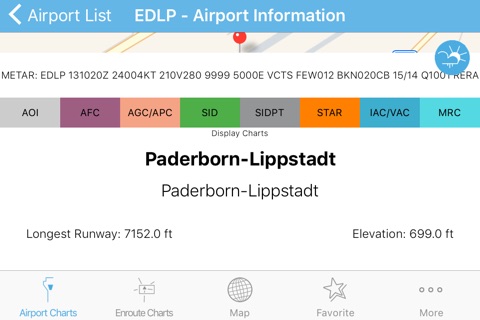
airport information with current weather information
• Favorite mode, add any airport to your favorite list and have quick access to it, including display there charts
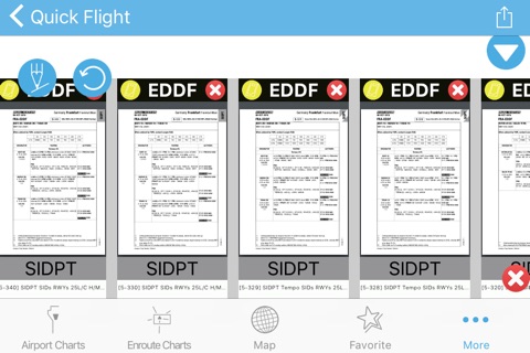
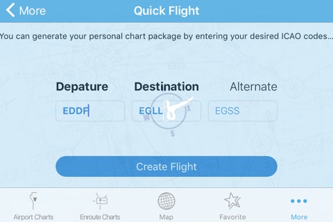
• Quick Flight for quick access to the relevant airport
charts
• Kneeboard mode, add unlimited charts for your next flight into the stack view and browse them without switching the menu
• Search and display all LIDO Enroute Charts including Overview
• Interactive map, that display included airports with METAR information and other information like elevation and runway lengh
• VATSIM ATC display on the interactive map, you can see the current online VATSIM Network ATCs including there frequency and more information
• Airport information and METAR datas
• Chart Display View include, preview of other charts from the current airport with fast chart switching, Quick "Add to Kneeboard" button
• ChartAirServer to display the Chart you currently view on your iOS Device on your (via Wifi connected) Computer by simply open it in the browser
*You will need a NavDataPro Charts Account that you can gain at www.aerosoft.com